Public Sector

Drones are revolutionizing agriculture and public sector initiatives by enhancing efficiency, precision, and sustainability.

Drone Inspections & Public Sector Services

GIS Surving Maping

SAV is revolutionizing GIS Surveying & Mapping with advanced drones and GIS technology. Their innovative solutions provide accurate, real-time data, benefiting industries like agriculture, urban planning, and environmental management for better decision-making.

Mining and Metals

SAV is revolutionizing mining and metals with advanced drone technology, making operations safer and faster. SAV drone solutions help mining companies boost productivity, cut costs, and stay ahead with smart, sustainable technology.

Energy & Utilities

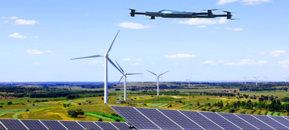
SAV is revolutionizing energy and utilities with advanced drones, making operations safer and more efficient. Unlike manual inspections, drones provide real-time monitoring, precise data, and easy access to tough spots - cutting costs, downtime, and risks.

Oil & Gas

SAV is revolutionizing the oil and gas industry with innovative drone technology and advanced mapping. By replacing slow, labor-intensive methods, drones deliver real-time insights, boost safety, streamline operations, and cut costs - helping companies work smarter and reduce risks.

Industrial Security

SAV is revolutionizing industrial security with advanced drone technology. Unlike traditional static cameras and human patrols, our drones offer real-time monitoring, high-resolution imaging, and wider coverage - boosting security while cutting costs.

Benefits of Using Our Drone Services

Smart Infrastructure Monitoring

Monitor infrastructure, ensure safety, and track environmental changes in real time. Act faster, allocate resources wisely, and build a smarter, safer future with drone technology.

Green Tech Efficiency

Reduce reliance on chemicals and embrace green tech solutions with real-time updates that help you work efficiently while protecting the environment and the communities you serve.

Reduce Costs, Boost Efficiency

Save taxpayer money on labor, fuel, and operational costs while improving efficiency. From infrastructure inspections to emergency response, drones help complete tasks faster and safer.

process

How It Works

01

Consultation & Needs Assessment

We visit farmers in their fields to understand their challenges—crop health, water supply, and pests—offering support and solutions for their prosperity.

02

Pre-flight Planning & Mapping

We analyze farmland using satellite images and plan precise flight routes, ensuring smooth and efficient drone operations for public sector agriculture

03

Data Collection

Our drones survey farms, capturing images and checking moisture levels to support farmers with healthier crops and better yields.

04

Data Processing & Analysis

We analyze data to create clear maps and reports, helping farmers easily understand their crop health, irrigation needs, and pest risks for better decision-making.

05

Actionable Recommendations

Our public sector services help farmers improve crop health, manage water efficiently, and apply the right treatments at the right time—ensuring better yields.

06

Ongoing Monitoring & Support

Drone surveys track crop growth, offering valuable insights to help farmers make better decisions and improve yields with public sector support.

FAQ'S

Drones provide real-time aerial insights, helping farmers monitor crop health, optimize irrigation, detect diseases, and improve spraying accuracy. This leads to higher yields, reduced costs, and better resource management.

We use specialized agricultural drones equipped with high-resolution cameras, multispectral sensors, and GPS-guided sprayers for precision farming.
Drones can be used for a wide range of crops, including wheat, rice, corn, soybeans, vineyards, orchards, and other high-value crops that require regular monitoring and precision treatment.
Yes! Drone spraying ensures targeted application, minimizing chemical use and preventing over-spraying, making it a viable option for organic farming when using approved bio-friendly pesticides and fertilizers.
NDVI (Normalized Difference Vegetation Index) helps identify plant health by detecting stress levels, nutrient deficiencies, and disease outbreaks early, allowing farmers to take timely action.